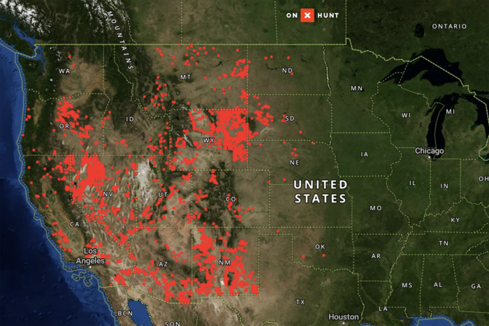
The Bureau of Land Management (BLM) has identified more than 6 million acres of federally managed public land for potential sale. Seventeen Western states contain parcels the BLM has listed as suitable for “disposal” in official Resource Management Plans (RMPs).
Now, for the first time, the public can see exactly where they are. OnX, in partnership with the Theodore Roosevelt Conservation Partnership (TRCP), has released an interactive mapping tool that visualizes these parcels across more than 160 BLM planning areas. This map provides the public with direct access to information that the government previously buried in hundreds of pages of legal documents and databases.
Users can search for locations they hunt, hike, or recreate in and instantly see if those lands are among those identified for potential sale. Each parcel includes data on the associated RMP and the year it was published. Some of the parcels have been on disposal lists for more than 40 years.
The Map
Explore your area to see which pieces of public land might be on the chopping block.
“Public lands, like those managed by the BLM, support 178.5 million outdoor recreation participants who rely on these landscapes to hunt, hike, fish, off-road, ski, climb, and bike,” onX CEO Laura Orvidas said in a press release.
“The outdoor community cherishes these places, and has recently fought fiercely to keep them public. Yet the land disposal process has historically been opaque, often buried in hundreds of pages of government documents. We created this map with TRCP to bring transparency to the land disposal process, to inform outdoor enthusiasts of nearby parcels, and to encourage lawmakers to uphold existing policies that safeguard the public interest when considering any land sales.”
Why These Parcels Were Flagged in the First Place
The BLM’s authority to sell land comes from the Federal Land Policy and Management Act of 1976. That law directed the agency to identify tracts that could support community development or improve management efficiency. Listing a parcel for disposal does not guarantee a sale, but it shows the BLM has already evaluated it as eligible.
Before a sale can take place, the BLM must provide public notice, accept public comment, and determine that the sale is in the public interest. It does not need congressional approval.
While that process may appear to offer a safeguard, BLM officials have not reevaluated many of the current disposal listings in decades. In some cases, BLM offices have carried forward old parcel lists from one RMP update to the next without reviewing whether those designations still make sense.
In the meantime, populations have grown, recreational use has increased, and many of these parcels are now more valuable to the public than ever before.
Finally, Transparency
The onX and TRCP map layers display “disposable” parcels along with detailed landscape features, including roads, nearby towns, and adjacent public lands. Users can click on any parcel to see its background, the RMP it comes from, and how long it has been under consideration.
The map includes data for 17 Western states, but it also shows a few outlier parcels where data is otherwise sparse.
OnX excluded Alaska due to incomplete federal data and complex legal conditions surrounding land ownership and transfers in the state. The company plans to update the map if additional data becomes available.
This map provides a powerful tool to help protect our public spaces. Through mobilized action and the pressures the outdoor community put on Congressional representatives, we were able to remove public land sales from the Trump administration’s latest budget reconciliation. Share this map with friends, family, and communities that value outdoor recreation and our public lands.
Read the full article here


